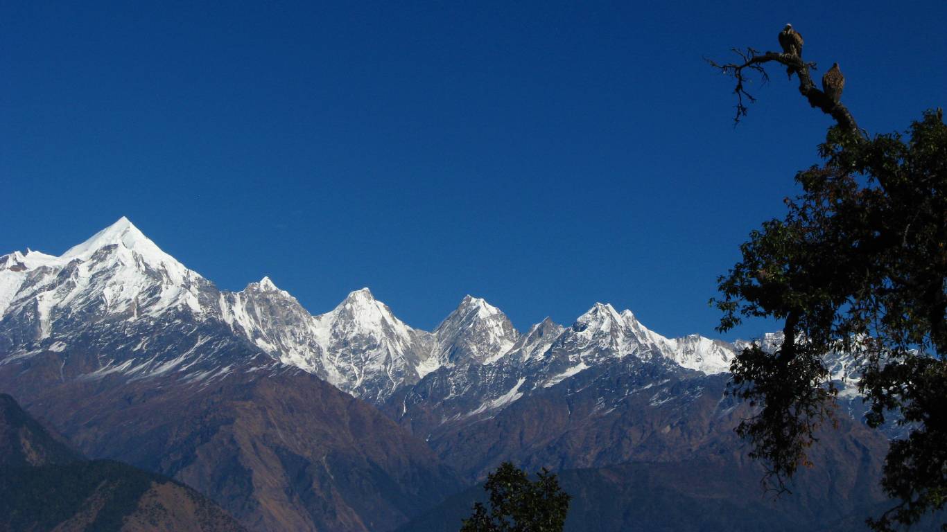
Panch Chulli Peaks
A meandering meadow surrounded by snowy peaks, offering an awe-inspiring view of the mystical land of Kumaon

The most visible symbol in the Munsiyari valley are the peaks of Panch Chulli, named after the five Pandava brothers from the Indian epic Mahabharata. The peaks represent their cooking hearths (chullis) where they cooked their last meal before ascending to heaven. From our lodge at dawn, you can get to watch a spectacular sunrise. In the evening, a little after sunset, at times you can be witness to a magnificent moonrise as well.
The Panch Chulli peaks lie in Eastern Kumaon region of Uttarakhand and form the watershed between the Gori Ganga and the Darma valley. The eastern approaches are through Sona and Meola Glaciers. The Uttari and Dakshini Balati glaciers guard the western approaches.
The peaks are numbered NW to SE;
Peak I (6355m/ 20851ft),
Peak II (6904m/22652ft),
Peak III (6312m/20710ft),
Peak IV (6334m/ 20782ft)
Peak V (6437m/21120ft).
Naming the peaks from west to east breaks with the tradition of giving the highest peak the lowest number, but the nomenclature has become too well established to be changed now.
Early Expeditions from the East
The mountaineering history of these peaks began with the British mountaineer Hugh Ruttledge (1929). He saw the group at close quarters from high up on the Sona Glacier. He examined the routes and thought that the north arete (sharp ridge) might be possible. After 21 years two teams examined the eastern approaches. WH Murray (1950) and his Scottish team followed the Ruttledge route. They intended to reach the north col and follow the northeast ridge; however, they found the terrain too difficult.
Just 20 days later came Kenneth Snelson (British) and J de V Graaff (South African). They reached the upper Sona Glacier by early September and found that its head was a cradle of 182m (600 ft) cliffs blocking the route to the northeast summit’s ridge. They too abandoned their attempt . After these attempts, the eastern approaches were left alone. Two more teams in 1970 and 1988 also tried them unsuccessfully.
Attempts from the West
The western approaches were tried one year after Murray. In 1951 Heinrich Harrer and Frank Thomas (Austrians) were joined by two Sherpas and a botanist. They pioneered the route through the Uttari Balati Glacier, bypassing three icefalls. Together with the Sherpas, Harrer reached the Balati plateau and examined the north and west ridges. They tried the west ridge, but a Sherpa fell off on hard blue ice. Harrer gave up. They spent only 16 days on the mountains but during that time they pioneered the route which was followed by all subsequent expeditions from this side.
First Ascents
The climbing history of the Panch Chulli group continued with two large expeditions from the Indo-Tibet Border Police. The first team in 1972 was led by Hukam Singh. They powered their way to the Balati Plateau via the Harrer route and made the first-ever ascent of peak I. Repeating their route, Mahendra Singh led another team in 1973. The entire route on the southwest ridge was fixed with almost 3000m (9843ft) of rope.
On 26th May 1973, 18 people climbed the summit of Panch Chuli II, the highest peak of the group.
The mountain was then left alone for some 18 years. In 1991 two routes were climbed via the eastern approaches by teams from the Indian Army. The first team followed the Sona Glacier, climbed the northeast slopes to reach above the north col and established a camp on the north ridge. The ridge was followed to the top, and thus the route suggested by Ruttledge in 1929 was finally completed after 61 years. The second army team followed Murray’s route to the upper Meola Glacier. They pitched a high camp following the southeast slopes to the east ridge. The summit team broke the cornice to reach the top, and thus the route suggested by Snelson-Graaff was also completed, after 41 years.

Last Climbs
The scene finally shifted back to the west. The Indian-British expedition 1992 (jointly led by Sir Chris Bonington and Harish Kapadia) followed the route along the Uttari Balati Glacier to the Balati Plateau. On the way the team divided into groups to climb Sahadev East (5757m/18889ft), Menaka (6000m/19686ft) and Rajrambha(6537m/21448ft). On peak II, a team of three climbed the southwest ridge. It was a hard climb on ice, keeping well away from the hanging cornices. Compared to the earlier ascent, only 60m (197ft) of rope was fixed on the ridge. This was only the second ascent of the southwest ridge, made after 19 years. Another team of two pioneered a new route up the steep and icy west ridge, with bivouacs. They descended the southwest ridge completing the traverse. Thus the route tried by Harrer was completed after 41 years.
The 1992 expedition later made the first ascent of peak V. On this peak Stephen Venables, a leading English mountaineer, fell while returning from the peak. He survived despite serious injuries and was airlifted in a daring helicopter rescue from the high camp.
Peak IV was climbed in 1995 by a team from New Zealand.
Peak III still remains unscaled, though it was attempted by two expeditions from Mumbai in 1996 and 1998, both of which resulted in accidents. There are some claims that Peak III was first climbed in the year 2001, but this has not been verified.
Other Adventure Treks
Munsiyari is the starting point for some of the most glamorous high-altitude treks in the world such as:
For more details, please visit our website www.trekkinginhimalayas.com
Nanda Devi Base Camp
Nanda Devi Base Camp and Milam Glacier
Ralam Valley and Birjegang Pass
Hotel in Munsiyari
Location: Munsiyari, Uttarakhand 262554
1.5km
FROM CITY CENTRE
50m
TRIBAL HERITAGE MUSEUM
1.5km
MAHESHWARI KUND
